Showing posts with label Map 7. Show all posts

Monday, January 9, 2017

Day 22 – Mollidgewock State Park, NH, to Rapid River, ME

U-2016-9-11 – 

Start: Mollidgewock St. Park, Osprey remote site.
End: Cedar Stump Campground, Campsite #5, right at the start of the Carry Road.
On the Way:  Androscoggin River, Errol, Umbagog Lake
Miles: 16.  Milestone 398.5.  Hooboy!
Map:  7, 8
Weather:  Thunderstorms in AM on Androscoggin, Windy but clear—mostly—through Errol to Umbagog Lake.

Map 8: Errol to Rangely, ME

Trail Overview

OUT OF NH!  New State, new map, and GOODBYE UPSTREAM nonsense!  I’m now on map 8/13, and state 5/5, and well into the 2nd half of the mileage!  WHOO!

Last NFCT Kiosk of NH!

Today’s been full of little struggles.  I’m fine and happy and (mostly) warm for now, but tomorrow I’ll probably be feeling the cold and the muscle ache.

Started out right before a long segment of rapid-tracking on the Androscoggin.  Was jamming along on it just fine when a morning downpour started.  After hoping for rain for a week (what am I saying, I’ve been making horrible promises to fearsome pluvial deities this whole trip…), I’d be loath to sit and pout because of a little precipitation, but when I saw thunder and lightning, I begrudgingly parked under a hemlock and consoled myself with a Clif Bar and waiting.  It lasted about half an hour, then I departed again, rain still coming down, up the rapid.  Got to wave to a fleet of Boyscouts huddled under tarps at the next group campsite up the river, and line past a couple be-wadered fishermen who were similarly sitting out the rain.

Next to the State Park proper, the river flattened out—the true “hallelujah” moment—all the way to Errol, our first town in Maine.  Picked up some groceries in Errol, including a local zucchini for $1 that was a steamy addition to my ramen soup this evening.  There’s an odd little set of rapid right below the dam next to Errol, and an even weirder campground/outfitter/guide service right along the shore.  Hand-painted signs, wooden tent platforms propped on cinderblocks, and a broken canoe with “Respect the waters” painted on the side welcoming you in.  It’s a homey place, and with sites right alongside the rapid stretch of the river, you could theoretically run your little playboat up the access road and down the rapids all day, go to sleep, wake up, and do it again.  They also have a generous policy of offering free camping to Through-paddlers, and when I got in at 1300 and told them it was too early for me to stop today, they graciously offered me a site on the other side of the lake at Cedar Stump, a handful of sites they owned.  The two proprietors were Eric and Maggie, with a very friendly dog.  I must remember to send Northern Waters/Saco Bound a thank-you.


Camping at Cedar Stump when it's NOT as windy as the gates of a Frozen-over Hell.  Looks quite nice.  Image via Northern Water's site: http://beoutside.com/

It was a long, windy battle across Lake Umbagog, even more taxing than Champlain/Bitabawgok, although a fraction of the mileage.  I was ready for that site by the end.  Lots more lakes to come—Dieter das Sea Boot is in his element.


The peatlands and river out of Errol lead straight into Umbagog Lake.  The Trail then goes out the Northeast corner, up to the mouth of the Rapid River.  Via the NH Division of Forests and Lands.

Things Learned: 

+ My deckbag (a cheap PVC thing I picked up in Long Lake, NY) is kind of toast.  I’m trying to downsize its contents.

+ Picked up some dray navy beans in Errol, and going to give bean-soaking a try in a plastic water bottle.  Fiber and protein yesplease.

+ Getting real good at upstream rapid-tracking.  Here’s hoping that stops being useful real soon.

+ Camping in the wind = COLD!  I’m wearing all the clothes I have tonight and pitched as far back in the woods as I could venture without having dreams of The Girl Who Loved Tom Gordon.  The wind is still sucking my heat away…  In the future, if you come across a windy site, keep on lookin.

Trail Magic: 

+ Lots of incredulous faces as I travelled upriver past the Molliwodge camp sites…

+ Errol General Store man (where I bought a strange assortment of groceries) asked if I was camping and threw in a free pear.

+ Managed to surf on some of Lake Umbagog’s whitecaps!  It was surreal: this tiny, deep little lake had the biggest waves of the trip yet.

Day 21 – West Milan, NH, to Mollidgwock State Park, NH

S-2016-9-10 

Start: Cordwell Campsite
End: Mollidgwock St. Park, Osprey remote site.
On the Way:  Upper Ammonoosuc River, West Milan, Androscoggin River, Pontook Reservoir
Miles: 16.6.  Milestone 374.5.  HALFWAY!
Map: 7

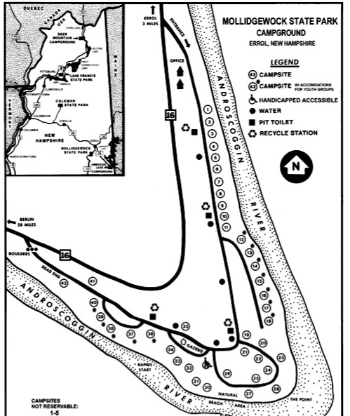
A map of Mollidgewock State Park (which I've been mispelling this whole time).  From http://www.mappery.com/Mollidgewock-State-Park-map
Well, I goofed.  I read the map and the guidebook to understand that “Osprey” site, with the same naming scheme and labelling protocol as every other site on the map, was one of these glorious free first-come, first-served NFCT primitive sites, like those I’ve been enjoying ever since Old Forge.  Instead, I found out it was a remote site of Molliwodge State Park, a couple miles up the Andro, and it was already booked.  I intruded on a very nice older couple with their 25’ glamping trailer.  It was getting dark and the Andro was rushing—enough so that the only way to proceed upstream was to carefully line along the shore—but they very graciously agreed to let me pitch my hammock off to the side of the spacious site.  Things were made less awkward because they had several friends over to sit around the fire, play loud classic rock (no objections), and drink the husband’s homemade dessert wine.  They offered me a glass (real glass!).  It was pretty good: plenty sweet and nice and clear, which is always hard to do with homebrews.  This was sangria, but apple wine is apparently also one of his specialties.  Good use of a crop that most people seem to let rot on the tree around here.

This bunch only lives 14 miles down the road from here, yet still brings this monstrous camper out to sit in another patch of woods around another fire ring every now and again.  Goes to show the strong grasp of camp culture around here.  They were very cheery retired folks—can’t be doing too bad for themselves with this camping rig.  They commented on the abnormally high number of spiders around, which I’d also noticed.  They also tried to declare that anthropomorphic climate change wasn’t happening.  I played the good guest and politely ended the conversation, rather than whipping out my mentally-prepared set of data to the contrary.

Pontook Reservoir, where I'd love to launch a (downstream) journey on the Androscoggin in the future!
This morning I finally got off the Upper Ammo in Groveton (with a great convenience store with great Whoopie pies), did a ~4mi portage to the Androscoggin, only to find that this weekend is one of the last where they’re letting the dam out full-tilt for whitewater paddlers.  Took one look at the raging current below the dam, decided my strength was better used elsewhere, and portaged the rest of the 1.5 miles up to the Pontook Resevoir.  Most of the Androscoggin was nice, glassy and slow-moving and wide, littered with pulp logs under-hull from the days of driving all the virgin timber downriver.  (The last log drive here was quite late, in 1964!)  Some of the sections have some really wicked current, though, which required some careful lining.  Hence my desperation to stop here at Osprey: lining becomes kind of dangerous in anything except full light.

Here’s to lots more lining tomorrow, hopefully right out of NH and the end of this map!

Things Learned:

+ Gord’s general store (the start of the Upper Ammo/Andro portage) carried some topical muscle relaxant that I’ve taken to calling “boyfriend cream” in my mind.  As in, it replaces one of the chief reasons for toting a boyfriend along, which is restorative backrubs.  I can’t wait to try it out, although I hope it’s not scented enough to draw the bugs.

Trail Magic: 

+ Thought I had lost my camp shoes, but they were just crammed way back in the stern.  Would have been sad times—manageable, but sad.

+ Saw 2 weasel-like critters—maybe mink—crossing the road during the portage.

Friday, December 30, 2016

Day 20 (!) – Connecticut River, NH, to West Milan, NH

F-2016-9-9

Start: Samuel Benton Campsite on Connecticut River, NH
End: Cordwell Campsite on the Upper Ammo
On the Way:  Connecticut River, Upper Ammonoosuc River, Stark
Miles: 25.8.  Milepost: 357.9
Map: 7

Every weekend, I forget about what weekends entail.  In this case, it entailed people staying at campsites for fun.  Novel concept.  This bunch has been nice enough, but their party included no fewer than four dogs, all of whom are fond of barking.  Fortunately the dogs went to sleep pretty readily (they have their own 2-man tent).  They brought loads of food and generously offered to share, so I had one of their all-beef hotdogs (those bizarre pink-dyed ones that New Hampshire folk seem to be so fond of), a protein bar, and some pretzels.  One of them is explaining how he tries to espouse minimalism by eating MREs and leaving his ground pad at home when he goes hammock camping in his sleeping bag…and he wonders why his backside gets cold.  Around their camp are no fewer than three coolers.  Campers can be a funny bunch.

That said,”camp culture” is definitely a palpable feeling up here in NH.  Every other building I pass seems to be a little camp shack covered in antlers.  I peer at them as I go by and mentally collect ideas for a little hermit house of my own for the future.  What do they do when they visit?  Hunt?  Ski?  Just hike around?  Spend time fixing up the shack?  We’re about 45 minutes from the White Mountains, so treating these as vacation homes with hiking nearby makes sense.  I dig it, whatever’s the true angle of this culture.

I’m really being quite unfairly biased against NH whenever I sneer at something in my mind, on account of how awful these rivers are at the moment.  Mr. Minimalist said that this is the lowest he’s ever seen the Ammo, period.  It’s pretty bad: I had to portage from Groveton to above Stark, about 5 miles along an undulating 2-lane highway, to get out of the continuous rock garden.  And after that, once I did put in, it was all S-curves and windy piddle streams before this campsite.  There’s not much that’s more demoralizing than taking your last 2 miles of the day at a pitiful, bank-crashing crawl.

The gorgeous little town of Stark, NH, with its landmark covered bridge.  Just a couple of miles down the road was the site of a WWII camp for German POWs.  Via Carol Smith.

Things Learned:

+ Pre-bed DEET application is a real, real important detail.

+ The dam on the Androscoggin releases on Wednesdays!  This should be fun.

+ Lots of Trump supporters out this way, which makes me a little afraid.

Trail Magic:

+ 2 Bald Eagles sighted today!

+ While toting Dieter along the road, a van with two older men pulled over.  Clutched in the hand of the passenger-side gent was the familiar NFCT map!  They were planning a paddle for the weekend and wanted a diagnosis.  I told them to look upstream.

Friday, December 23, 2016

Day 19 – Nulhegan Basin, VT, to Connecticut River, NH

R-2016-9-8

Start: Stealth Camp below Upper Gorge on Nulhegan River
End: Samuel Benton Campsite on Connecticut River, NH
On the Way: Nulhegan River, Bloomfield/North Stratford, Connecticut River
Miles: ~19.  Milepost: 332!
Weather: Clear during day, light rain in PM.
Map: 6, 7


Map 7: North Stratford, NH/Bloomfield, VT to Errol, ME
Trail Overview

Slowly but surely getting back into my high-mileage days!  Today seemed like “the Trail in miniature,” starting with 2.5 miles or so of lining, them some very careful paddling through a rock garden, then about 6 miles of portaging, a mini-town day in North Stratford, NH, with a scrumptious egg sandwich at the General Store and Deli, then a good long coast down a wide, swift river, getting just a taste of down-stream paddling.  One tantalizing taste…

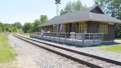
The North Stratford Library is inside this tiny, historic train station.  Real cute and cozy.  Via http://www.stratfordnhlibraries.com/
Now I’m camped at an official NFCT campsite, fedded and bedded with a cedar scrapwood fire going to keep away the bugs.  It’s a little copse of giant oak trees with a picnic table and fire ring, with a view of the river and a private beach, and it’s divine.  The beavers have started splashing and a little toad is hopping around my spread-out maps.  Friends of the campsite’s owner have stopped by to say hello, and they offered the awning of their nearby RV if the rain picks up.  There’s even a deluxe privy here, and a register.  (Teton beat me here by about four hours!  Must have passed me in town…).  Life is good.

Body-wise, my night in the sand did orthopedic wonders for my back.  I have a hypothesis that the continual hammock nights is what’s agitating it: we’ll test that tonight.  I could always alternate between hammocking and tarping on the ground if that’s the case.  Such is the beauty of tarp camping.  Just as soon as the back seemed placated, I started getting one of my grumpy-making headaches.  I had some caffeinated tea, which helped a little bit, but these headaches are Not Good ™.

Other than that, I haven’t had a solid BM in a week (need more veggies, rargh), my camp shoes I wore on my Zero Day gave me a blister ONLY on my left heel, my right wrist (AKA, my power arm) tingles sometimes and is usually swollen when I wake up, and my right pinky toenail has gone black.  Hopefully it’ll fall off, so I’ll be down to one deformed foot anomaly.  Oh, and the deli lady in town told me my hair looked like Peter Pan’s.  But that’s enough TMI body complaints.  For at least one journal.  These things matter a lot more when you have little else to focus on.

I made a quick wish-list this evening.  The only items I could think to add were more fruits and veggies.  I’m pleased to say that I have everything else I need.  It feels like a lot of gear on any given portage, but I’ve used each and every item at least once, barring the maps to come and the scarier of the bandages in the First Aid kit.  It’s a gratifying feeling, very freeing, and it’s not too much of a jump from a kit like this one to an all-purpose adventuring kit.  Such as for the AT!  Or PCT!  Dangerous thoughts, indeed.

Things Learned: 

+  I’ve been having trouble getting the Jetboil to light recently: there’s a little button to click click click once the gas valve is open, and it’s rarely making enough spark to get the stove lit.  Bad design.  I bumped the tiny, delicate little ignitor wire more squarely over one of the gas holes on the burner, which seems to have marginally improved the probability of lighting it…  But it makes me sad to think of all the fuel I’ve wasted before figuring that out.  Boo, Jetboil.

[NOTE: I ended up giving up on the ignitor button and simply lighting the stove with my emergency lighter later on.  It works fine, but between that and campfire lighting I did use up the lighter by the end of the trip.]

+ Gotta keep your eye on the strongest current!  Ended up on sandbars more often than I’d like to admit today, simply because the path of the deepest channel (AKA, where the water’s moving fastest on the surface) switched to the other side of the river.

Trail Magic: 

+ This campsite.  Thanks, NFCT!

+ Sign of Teton.  Good that he gets some time in the lead.  :P